


HAMILTON, Jackson County, Indiana
About
Outline

Summary
| Unique Area Identifier | 577918 |
| Name | HAMILTON |
| County | Jackson County |
| State | Indiana |
| Area (square miles) | 63.34 |
| Land Area (square miles) | 62.58 |
| Water Area (square miles) | 0.76 |
| % of Land Area | 98.80 |
| % of Water Area | 1.20 |
| Latitude of the Internal Point | 38.97787690 |
| Longtitude of the Internal Point | -85.98075010 |
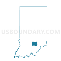
Maps

Graphs
Select a template below for downloading or customizing gragh for HAMILTON, Jackson County, Indiana


Neighbors
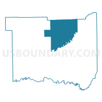
Neighoring Voting District (by Name) Neighboring Voting District on the Map
- BROWNSTOWN TWP. EAST, Jackson County, IN
- BROWNSTOWN TWP. WEST, Jackson County, IN
- JACKSON 5000, Bartholomew County, IN
- JACKSON 7, Jackson County, IN
- PERSHING, Jackson County, IN
- REDDING WEST, Jackson County, IN
- WAYNE 5700, Bartholomew County, IN
Top 10 Neighboring County Subdivision (by Population) Neighboring County Subdivision on the Map
- Jackson township, Jackson County, IN (20,042)
- Brownstown township, Jackson County, IN (5,552)
- Redding township, Jackson County, IN (4,233)
- Wayne township, Bartholomew County, IN (3,815)
- Hamilton township, Jackson County, IN (1,660)
- Pershing township, Jackson County, IN (1,394)
- Jackson township, Bartholomew County, IN (949)
Top 10 Neighboring Unified School District (by Population) Neighboring Unified School District on the Map
- Bartholomew County School Corporation, IN (71,088)
- Seymour Community Schools, IN (27,072)
- Brownstown Central Community School Corporation, IN (10,375)
Top 10 Neighboring State Legislative District Lower Chamber (by Population) Neighboring State Legislative District Lower Chamber on the Map
- State House District 66, IN (64,746)
- State House District 65, IN (64,454)
- State House District 73, IN (62,643)
Top 10 Neighboring State Legislative District Upper Chamber (by Population) Neighboring State Legislative District Upper Chamber on the Map
Top 10 Neighboring 111th Congressional District (by Population) Neighboring 111th Congressional District on the Map
Top 10 Neighboring Census Tract (by Population) Neighboring Census Tract on the Map
- Census Tract 9675, Jackson County, IN (7,782)
- Census Tract 115, Bartholomew County, IN (7,602)
- Census Tract 9680, Jackson County, IN (5,344)
- Census Tract 9681, Jackson County, IN (4,207)
- Census Tract 9677, Jackson County, IN (3,765)